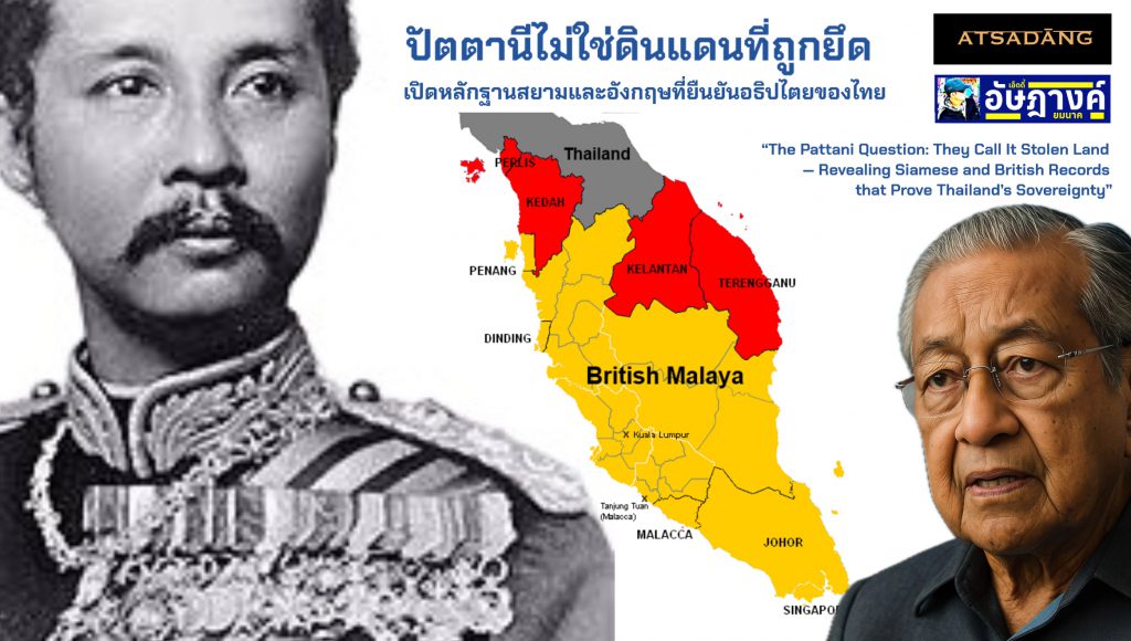
“ปัตตานีไม่ใช่ดินแดนที่ถูกยึด: เปิดหลักฐานสยามและอังกฤษที่ยืนยันอธิปไตยของไทย”
โดย อัษฎางค์ ยมนาค
คำนำ:
การเมืองของประวัติศาสตร์ และมายาคติแห่งการ “สูญเสียดินแดน”
เมื่อไม่นานมานี้ ดร.มหาเธร์ โมฮัมหมัด อดีตนายกรัฐมนตรีผู้ทรงอิทธิพลของมาเลเซีย ได้จุดกระแสความเคลื่อนไหวในระดับภูมิภาค ด้วยการโพสต์ข้อความเรียกร้องความเห็นใจต่อ “การสูญเสียดินแดนของชาวมลายู” โดยมีนัยว่าพรมแดนของมาเลเซียในปัจจุบันถูกจำกัดเพราะดินแดนบางส่วน “ตกเป็นของประเทศเพื่อนบ้าน” ซึ่งในที่นี้หมายถึงประเทศไทย
แม้วาทกรรมลักษณะนี้อาจปลุกเร้าอารมณ์ของผู้คนบางกลุ่มได้ แต่ก็มีความเสี่ยงที่จะ ตอกย้ำมายาคติแห่งการถูกกดขี่ ซึ่งอิงอยู่กับการตีความทางการเมือง มากกว่าข้อเท็จจริงทางประวัติศาสตร์ หากปราศจากวิจารณญาณในการแยกแยะวาทกรรมออกจากความจริง ก็อาจทำให้สังคมตกอยู่ในกับดักของอดีตที่ถูกบิดเบือน และยิ่งถ่วงรั้งประเทศเกิดใหม่ในภูมิภาคให้ไม่สามารถยืนหยัดด้วยอธิปไตยทางความคิดของตนเองได้
ประเทศไทย ไม่เคย “ยึด” ดินแดนจากมาเลเซีย เพราะในห้วงเวลานั้น มาเลเซียยังมิได้มีสถานะเป็นประเทศ ดินแดนที่เราเรียกว่า มลายา หรือ คาบสมุทรมลายู ในอดีต ไม่ใช่รัฐเดี่ยวที่มีอำนาจอธิปไตยแบบรัฐสมัยใหม่ แต่เป็นกลุ่มของรัฐสุลต่านอิสระ ที่แยกอำนาจกันปกครอง กระจัดกระจาย และต่างมีความสัมพันธ์หรือยอมรับอำนาจจากมหาอำนาจรอบข้าง ไม่ว่าจะเป็นกรุงศรีอยุธยา มะละกา หรือชวา
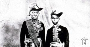
ในบรรดารัฐเหล่านี้ รัฐปัตตานี มีความโดดเด่นในฐานะรัฐมลายูที่มีความสัมพันธ์กับรัฐใกล้เคียงอย่างกลันตัน ตรังกานู และยะโฮร์ แต่ก็ยอมรับอำนาจของสยามในฐานะ “รัฐบรรณาการ” กล่าวคือ แม้จะมีความเป็นอิสระในการปกครองภายใน แต่ก็แสดงความสวามิภักดิ์ต่อกรุงศรีอยุธยาและต่อเนื่องมายังกรุงเทพฯ โดยการส่ง “เครื่องราชบรรณาการ” เช่น ดอกไม้ทอง ดอกไม้เงิน เป็นประจำ
เพื่อทำความเข้าใจอย่างถูกต้องถึงความสัมพันธ์ระหว่างสยามกับหัวเมืองมลายู และเพื่อตอบโต้ข้อกล่าวหาที่บิดเบือนในเชิงหลักฐาน จึงขอนำเสนอข้อเขียนชุดนี้ โดยอ้างอิงจาก “พระราชพงศาวดารรัชกาลที่ 5” พระนิพนธ์ของสมเด็จฯ กรมพระยาดำรงราชานุภาพ ซึ่งถือเป็นหลักฐานสำคัญของรัฐ เพื่อเปิดพื้นที่ให้ข้อเท็จจริงทางประวัติศาสตร์ได้ยืนเคียงข้างวาทกรรมร่วมสมัยอย่างมีเกียรติ
_____________________________________________
ปัตตานี หัวเมืองมลายู และประเทศราชของไทย
ตอนที่ 1
เนื้อหาต่อไปนี้คัดลอกมาจาก พระราชพงศาวดารรัชกาลที่ 5 พระนิพนธ์สมเด็จกรมพระยาดำรงราชานุภาพ
เมื่อตั้งกรุงรัตนโกสินทร์ประจวบกับสมัยมหาสงครามคราวเอมปเรอนโปเลียนที่ 1 ในยุโรป มหาสงครามครั้งนั้นอังกฤษได้เป็นฝ่ายชนะ ได้เมืองขึ้นจากฝรั่งเศสและฮอลันดาที่มีอยู่ในเอเซียไปเป็นของอังกฤษ
รัฐบาลอังกฤษได้มอบอำนาจแก่บริษัทอีสต์อินเดีย ให้มาลงทุนตั้งค้าขายอยู่เป็นหลักแหล่ง และได้ช่วยขยายอาณาเขตของอังกฤษในอินเดียมาแต่ก่อนแล้ว โดยการให้บริษัทอีสต์อินเดียมีอำนวยการปกครองเหมือนเป็นรัฐบาล โดยอังกฤษได้แต่งตั้งผู้สำเร็จราชการ Governor General คนไทยเรียกว่าเจ้าเมืองบังเล่า เพราะตั้งอยู่ที่เมืองเบงกอล (Bengal)
บริษัทอินเดียได้ปกครองอาณาเขตมากขึ้นก็คิดขยายการค้าผลประโยชน์ให้กว้างขวางออกไปจึงเที่ยวเสาะหาที่ตั้งสถานีเป็นหลักแหล่งสำหรับค้าขายในระหว่างอินเดียกับจีน
อังกฤษเริ่มมาเกี่ยวข้องกับประเทศสยามในสมัยนี้ด้วยมาขอเช่าเกาะปีนัง (ซึ่งแปลว่า เกาะหมาก) จากเจ้าเมืองไทร (ไทรบุรี) เป็นที่ตั้งสถานีของบริษัทในสมัยรัชกาลที่ 1
เมื่ออังกฤษตั้งสถานีที่เกาะปีนังมั่นคงแล้วได้ขอเช่าเกาะสิงคโปร์จากสุลต่านเมืองมัว ตั้งเป็นสถานีสาขาขึ้นอีกแห่งหนึ่ง (ไทยเราเรียกสิงคโปร์ว่าเมืองใหม่) แต่นานเข้าอังกฤษก็เริ่มมีความคิดที่จะเอาเมืองมลายูทั้งปวงไว้ในอำนาจ
ในสมัยที่กล่าวมานี้ความประสงค์ของฝรั่งมีเพียงจะค้าขายให้สะดวกยังมิได้คิดจะเข้ามาเกี่ยวข้องถึงการบ้านเมืองความคิดของฝรั่งมาเริ่มกลายเป็นมหาอำนาจในการเมืองตั้งแต่อังกฤษรบชนะจีน
ในแผ่นดินรัชกาลที่ 2 นั้นพม่าคิดจะยกกองทัพใหญ่มาตีเมืองไทย ในขณะที่เจ้าพระยาไทรบุรีเกิดเป็นอริกับเจ้าพระยานครศรีธรรมมราช (น้อย ณ นคร) ซึ่งเป็นผู้กำกับหัวเมืองมลายู (ทั้งนครศรีธรรมราชและหัวเมืองมลายูนั้นขึ้นตรงกับไทย โดยกรุงรัตนโกสินทร์ได้มอบอำนาจให้เจ้าพระยานครศรีธรรมมราชเป็นผู้ดูแลหัวเมืองมลายูอีกทีหนึ่ง)
พม่าจึงได้มาเกลี้ยกล่อมเจ้าพระยาไทรบุรี ทำให้เจ้าพระยาไทรบุรีเอาใจไปเข้ากับพม่า โดยรับจะยกกองทัพมาตีเมืองนครศรีธรรมราชพร้อมกับพม่ามาตีกรุงเทพ แต่ความความทราบมาถึงกรุงเทพฯ เสียก่อน
พระบาทสมเด็จพระพุทธเลิศหล้านภาลัยจึงโปรดให้เจ้าพระยานครฯ ยกกองทัพไปตีเมืองไทรบุรีเมื่อปีมะเส็งพ.ศ. 2364 เจ้าพระยาไทรบุรีสู้ไม่ได้ก็หนีไปอาศัยอังกฤษอยู่ที่ปีนัง ในเหตุการณ์นั้นฝ่ายไทยต่อว่าอังกฤษ แต่อังกฤษก็ตอบว่าไม่ได้รู้เห็นเป็นใจด้วย แต่ก็ไม่ห้ามปราม เพียงแต่จะขอให้ไทยคืนเมืองให้เจ้าพรยาไทรบุรี ทำให้ไทยกับอังกฤษก็เกิดบาดหมางกันขึ้นจนถึงเกือบจะรบกันในครั้งนั้น
แต่เผอิญอังกฤษไปมีเหตุเกิดรบกับพม่าครั้งที่เมื่อปีวอกพ.ศ. 2367 อันเป็นช่วงต้นรัชกาลที่ 3 ทำให้อังกฤษหันมาทำไมตรีชวนไทยให้เป็นพันธมิตร ช่วยกันตีเมืองพม่า
เมื่อชนะพม่าแล้วอังกฤษกับไทยจึงทำหนังสือสัญญากันเมื่อปีจอ พ.ศ. 2369 เป็นหนังสือสัญญาฉบับแรกที่ไทยทำกับต่างประเทศในสมัยกรุงรัตนโกสินทร์ เรียกกันว่าสัญญาเบอร์นี่ตามนามของนายร้อยเอกเฮนรี่เบอร์นี่ผู้เป็นธูปมาทำหนังสือสัญญานั้น มีเนื้อความว่า
1. อังกฤษรับจะเอาตัวเจ้าพระยาไทรบุรีไปไว้เสียเมืองอื่น มิให้มารบกวนไทยที่เมืองไทรบุรีได้
2. ไทยรับจะไม่รบพุงแผ่อาณาเขตจากเมืองไทรบุรีต่อลงไปทั้งเมืองแประ และเมืองสลางอ
3. ทั้งอังกฤษและไทยสัญญากันว่าจะไม่เข้าไปเกี่ยวข้องถึงการภายในบ้านของเมืองกะลันตันและเมืองตรังกานู ซึ่งได้มาสวามิภักดิ์ยอมขึ้นต่อไทยเมื่อในรัชกาลที่ 1 (ข้อมูลตรงนี้เป็นหลักฐานที่ชัดเจนว่า อังกฤษก็ยอมรับว่า เมืองกะลันตันและเมืองตรังกานู เป็นเมืองขึ้นของไทยมาตั้งแต่สมัยรัชกาลที่ 1 )
ความข้างต้นดังกล่าว จะสังเกตุได้ว่า เมื่อตอนทำสัญญาไม่ได้กล่าวเมืองไทรบุรีและเมืองปัตตานี สาเหตุก็เพราะเมืองไทรบุรีและเมืองปัตตานีเป็นเมืองที่ขึ้นอยู่กับไทยมาแต่เดิม
แต่ต่อมาเมื่อทรงโปรดให้ทายาทที่เป็นเชื้อสายเจ้าพระยาไทรบุรีได้กลับคืนไปครองเมืองไทรบุรี อังกฤษก็ได้โอกาสขอให้เติมเมืองไทรบุรีเขาไปในท้ายสัญญา อันเป็นมูลเหตุที่อังกฤษจะเอาเมืองไทรบุรีและเมืองกะลันตัน ตรังกานูไปจากไทยในรัชกาลที่ 5
เรื่องที่เกี่ยวข้องกับอังกฤษที่กล่าวตอนนี้เก็บเนื้อความมาจากจดหมายเหตุเก่าที่ราชบัณฑิตยสภาได้ขอคัดสำเนามาจากหอสมุดกระทรวงอินเดีย
การที่ไทยกับอังกฤษทำหนังสือสัญญากันครั้งนั้นไม่ได้ทำด้วยรักชอบหรือไว้ใจกัน หากมีเหตุความจำเป็นด้วยกันทั้งสองฝ่ายจึงได้ทำหนังสือสัญญา
ในการที่ไทยทำหนังสือสัญญากับฝรั่งต่างชาติในสมัยรัชกาลที่ 4 ถ้าหากจะมีผู้คิดสงสัยว่าเมื่อทำสัญญากับอังกฤษโดยรู้ว่าเสียเปรียบ แล้วเหตุใดจึงยอมทำกับชาติอื่นๆ ต่อไปอย่างเดียวกัน
ข้อนี้เป็นด้วยเพราะพระบาทสมเด็จพระพระจอมเกล้าเจ้าอยู่หัวทรงพระราชดำริเห็นว่า ถ้าทำสัญญาเช่นนั้นกับชาติหนึ่งชาติใดแต่ชาติเดียว ฐานะของประเทศสยามก็จะเหมือนอยู่ในการจับจองของชาตินั้น ถ้าทำให้เหมือนกันเสียหลายชาติ แม้เสียเปรียบในข้อสัญญา ก็ได้เปรียบที่เป็นอิสรภาพมั่นคง เพราะฉะนั้นต่อเมื่อฝรั่งชาติอื่นขอทำสัญญาจึงรับทำโดยง่าย
ข้อความตรงนี้คือกุศโลบายในการต่างประเทศอันแยบยลของในหลวงรัชกาลที่ 4 ที่รัชกาลต่อๆ มาก็ถือปฏิบัติตามกัน นั้นคือการรักษาสมดุลทางการเมืองระหว่างประเทศ โดยไม่เข้าข้างเอนเอียงไปทางมหาอำนาจใดอำนาจหนึ่ง
สรุป
ปัตตานี ไทรบุรี กะลันตันและตรังกานู ล้วนเป็นเมืองที่ขึ้นกับกรุงเทพฯ มาตั้งแต่ต้นรัชกาลที่ 1 (เป็นอย่างน้อย) ซึ่งอังกฤษก็รับรองว่าเป็นตามนั้น แต่ด้วยอำนาจและอิทธิพลในการสร้างอาณานิคมของอังกฤษ ที่เกิดขึ้นหลังจากอังกฤษรบชนะจีน ทำให้อังกฤษแผ่อำนาจยึดครองพม่า มลายูและสิงคโปร์ไปเป็นอาณานิคมของตน
เหลือเพียงไทยประเทศเดียวที่รอดพ้นการตกเป็นอาณานิคมของอังกฤษมาได้ ด้วยเพราะปรีชาสามารถของสถาบันพระมหากษัตริย์ของไทย
แต่สงครามย่อมต้องมีการสูญเสีย ซึ่งสิ่งที่ไทยสูญเสีย คือดินแดนบางส่วนซึ่งเป็นส่วนน้อยเท่านั้น
ในที่นี่ก็คือ ไทยเราเสีย ไทรบุรี กะลันตันและตรังกานู ไปให้กับอังกฤษ และอังกฤษก็รวม 3 เมืองนั้นให้เป็นประเทศมาเลเซีย ในขณะที่ ปัตตานี ซึ่งขึ้นกับไทยมาตั้งแต่สมัยอยุธยาต่อเนื่องถึงกรุงรัตนโกสินทร์ก็ยังคงอยู่กับไทยมาจนถึงปัจจุบัน
ตอนต่อไป จะเอาหลักฐานจากฝรั่งชาติมหาอำนาจตะวันตกที่บันทึกไว้ว่า ปัตตานี ไทรบุรี กะลันตัน ตรังกานูและตลอดไปสุดแหลมมลายูเคยเป็นของไทยมาตั้งแต่สมัยกรุงศรีอยุธยา
_____________________________________________
ปัตตานี หัวเมืองมลายู และประเทศราชของไทย
ตอนที่ 2
อังกฤษส่งคนข้ามาในสยามตั้งแต่สมัยรัชกาลที่ 3 โดยคนแรกๆ เป็นคนของบริษัทอีสต์อินเดีย ชื่อ ร้อยโท เจมส์ โลว์ โดยเข้ามาสืบราชการลับ ตั้งแต่นครศรีธรรมราชไปถึงหัวเมืองมลายู
ในครั้งนั้น เจมส์ โลว์ ได้นำสิ่งใหม่มาสู่ราชสำนักสยามนั่นก็คือแผนที่ทวีปเอเชีย แต่ในสมัยนั้นคนไทยยังไม่เข้าใจถึงความสำคัญของแผนที่ จนกระทั่งผ่านไปถึงสมัยรัชกาลที่ 4 มีบาทหลวงคนหนึ่งชื่อ ‘ปาเลกัวซ์” ถ้าใครได้ดูภาพยนตร์บุพเพสันนิวาส 2 จะนึกออกว่า ปาเลกัวซ์ ก็คือนักบวชฝรั่งที่เป็นอาจารย์ของนางเอกในเรื่อง
ปาเลกัวซ์ ผู้นี้ถ้าเทียบเคียงกับปัจจุบันก็คือ NGO นั้นเอง ปาเลกัวซ์ เดินทางเข้ามาฝั่งตัวอยู่ในสยามกว่า 30 ปีจนรัชกาลที่ 4 ให้ความสนิทสนม โดยเบื้องหน้าของเขาคือนักบวชสอนศาสนาคริสต์ แต่มีเบื้องหลังเป็นงานสืบราชการลับ
ในปีพ.ศ. 2397 ปาเลกัวซ์ ได้แต่งตำราชื่อ “Description de Royaume Thai ou Siam’ พิมพ์ที่ฝรั่งเศส ซึ่งถือเป็นคัมภีร์สำคัญเกี่ยวกับสยามประเทศ ซึ่งเปิดเผยข้อมูลเชิงลึกของกรุงรัตนโกสินทร์และชาวสยาม ทั้งการปกครอง วิถีชีวิต ความรู้สึกนึกคิด มีรายละเอียดครอบคลุมทั้งความรู้ทางด้านประวัติศาสตร์และภูมิศาสตร์อย่างละเอียด ซึ่งความรู้ทั้งหมดนั้นเกิดจากการใช้ชีวิตในเมืองสยามตลอดจนถึงการคลุกคลีกับคนท้องถิ่นเป็นเวลาหลายสิบปี
ตำราของเขาเป็นคัมภีร์ที่ข้าราชการ นักการทหารและนักการทูตชาวตะวันตกทุกชาติต้องศึกษา หรือเป็นตำราที่ใช้เตรียมตัวก่อนจะมาถึงเมืองไทย
เนื้อหาสำคัญตอนหนึ่งระบุว่า
ประเทศที่ชาวยุโรปเรียกว่า สยาม นั้นเป็นชื่อเรียกชนชาติผิวคล้ำ ซึ่งเป็นที่มาของคำว่า”สยาม” แต่ชาวพื้นเมืองเรียกตัวเองว่า”ไทย” ซึ่งแปลว่า “อิสระ”
สยามทางเหนือมีอาณาเขตจรดเขตหัวเมืองลาวหลายหัวเมือง (หมายถึงล้านนา) อันประกอบด้วยเชียงใหม่ ลำพูน ลำปาง เมืองแพร่ เมืองน่าน เมืองหล่มสัก หลวงพระบาง
ทางทิศตะวันออกมีส่วนหนึ่งของอาณาจักรกัมพูชา เมืองโคราชกับหัวเมืองลาวอีกหลายหัวเมืองไปจรดประเทศญวน
ทิศตะวันตกจรดทะเลและอาณานิคมอังกฤษ
ทางใต้ยังมีอาณาจักรนครศรีธรรมราชกับรัฐมลายาเล็กๆ อีก 4 รัฐ เกดาห์ ปัตตานี กลันตัน และตรังกานู
โดยก่อนที่พวกชาวปอร์ตุเกศจะข้ายึดครองมะละกา อาณาเขตของประเทศสยามทอดยาวไปตลอดเลยมลายาจนกระทั่งจรดสิงคโปร์
(เห็นบันทึกประวัติศาสตร์ตรงนี้ไหม ว่าอาณาเขตของราชอาณาจักรสยามตั้งแต่สมัยกรุงศรีอยุธยามีอาณาเขตไปสุดถึงสิงคโปร์)
ต่อมาโดยการรุกเร้าและสนับสนุนของอังกฤษบรรดารัฐยะโฮร์ รัมโบว์ เซลังงอร์ ปาหัง และเประห์ ก็หลุดลอยจากมหาอาณาจักรและผู้เป็นเจ้าอาณานิคมไป โดยอาณาเขตของประเทศสยามยุคปัจจุบัน(หมายถึงในสมัยรัชกาลที่ 4) จึงไปสิ้นสุดที่ตรังกานู
ในบรรดาเจ้าของรัฐเล็กๆ เหล่านั้น ทั้ง ลาว เขมรและมลายู ที่มีฐานะเป็นเมืองขึ้นของกรุงสยาม มีภาระต้องส่งดอกไม้เงินและทอง ไปถวายพระเจ้ากรุงสยามทุกระยะ 3 ปี และมีหน้าที่เกณฑ์พลเมืองไปสมทบกองทัพเมื่อพระเจ้าแผ่นดินต้องการ
นอกจากนี้รัฐเหล่านี้แต่ละรัฐยังต้องส่งส่วยประกอบด้วยดีบุก งาช้าง กำยาน ขี้ผึ้ง กระวาน ครั่ง ไม้สักและผลิตผลอื่นๆแตกต่างกันไปตามสภาพภูมิประเทศอีกด้วย ซึ่งเป็นไปตามประเพณีเท่านั้นไม่ได้ตราเป็นกฎหมายตายตัว
ตำแหน่งเจ้าเมืองประเทศราชมักจะสืบทอดกันตามสายโลหิตเช่นบุตรดำรงตำแหน่งสืบต่อจากบิดาหรือโดยพระราชอัธยาศัยของพระเจ้าแผ่นดิน
สยามมีแผ่นดินอันอุดมสมบูรณ์ โคลนตมของแม่น้ำได้ทำให้พื้นแผ่นดินอุดมไปด้วยปุ๋ยอยู่ทุกปี โดยแทบจะไม่ต้องบำรุงพื้นดินเลย ก็ได้ต้นข้าวกอใหญ่ อันมีรถดีวิเศษ ซึ่งไม่เพียงแต่พอเลี้ยงประชาชนพลเมืองเท่านั้น แต่ยังส่งออกไปขายยังเมืองจีนและที่อื่นๆ
สรุป
หัวเมืองมลายูจนสุดสิงคโปร์เคยเป็นเมืองขึ้นของสยามมาตั้งแต่กรุงศรีอยุธยา ก่อนที่จะเหลือเพียงไปสิ้นสุดที่ตรังกานูในต้นกรุงรัตนโกสินทร์ และสุดท้ายในสมัยรัชกาลที่ 5 ก็มีปัตตานีเป็นดินแดนใต้สุดของไทย
ซึ่งนี่คือบันทึกประวัติศาสตร์ที่ชาวตะวันตกถือว่าเป็นคัมภีร์ในการศึกษาเกี่ยวกับประเทศสยาม ของ บาทหลวงปาเลกัวซ์ นักบวชชาวตะวันตกที่มาอยู่อาศัย, ศึกษาและสอดแนมอยู่ในเมืองไทยมากกว่า 30 ปี
อัษฎางค์ ยมนาค
_____________________________________________
“The Pattani Question: They Call It Stolen Land — Revealing Siamese and British Records that Prove Thailand’s Sovereignty”
By Eddie Atsadāng Yommanāk
Introduction: The Politics of Historical Narratives and the Myth of Loss
In recent weeks, former Malaysian Prime Minister Dr. Mahathir Mohamad, a highly influential statesman in Southeast Asia, stirred regional discourse by posting a statement lamenting the “loss of Malay lands.” His remarks implied that much of Malaysia’s current territorial limitations stem from lands once “taken” by neighboring countries—implicitly pointing toward Thailand.
While such sentiments may resonate emotionally with certain audiences, they also risk reinforcing a victimhood narrative rooted in mythologized oppression rather than historical accuracy. Without a discerning lens to separate nationalist rhetoric from verified historical fact, such discourse can obscure the complexity of regional history and hinder the ability of emerging nations to stand firmly on their own intellectual foundations.
The Kingdom of Thailand has never “seized” land from Malaysia—because Malaysia, as a nation-state, did not exist prior to 1826. The territory known today as Peninsular Malaysia was, in earlier centuries, a patchwork of independent sultanates, loosely organized and politically fragmented. These Malay polities, including Pattani, Kelantan, Trengganu, and Kedah, were never unified under a single sovereign entity. Instead, they frequently acknowledged the suzerainty of stronger neighboring powers—Ayutthaya, Malacca, or even Java—depending on regional dynamics.
Among them, Pattani stands out as a prominent Malay state that had long-established tributary relations with Siam. Though it retained local autonomy, Pattani regularly paid tribute to the Siamese court—first in Ayutthaya, and later in Bangkok—through formal ceremonies involving symbolic offerings such as the golden and silver trees (dokmai thong, dokmai ngoen). This tributary system, far from being colonial subjugation, reflected the historical norms of regional diplomacy and layered sovereignty common in pre-modern Southeast Asia.
To understand the true political relationship between Siam and the Malay states—and to respond with evidence to revisionist claims—this article turns to primary historical sources, particularly the Royal Chronicle of King Rama V, as written by Prince Damrong Rajanubhab. It is the first in a series that seeks to restore historical clarity to an increasingly politicized past.
_____________________________________________
Pattani, the Malay States, and Siam’s Tributary System: Part I
By Atsadang Yommanak
Introduction
This essay explores the historical relationship between Siam (Thailand) and the Malay states—specifically Pattani, Kedah, Kelantan, and Trengganu—based on royal chronicles and official documents from the reign of King Rama V. It also reflects on Siam’s strategic foreign policy in response to British colonial expansion in Southeast Asia.
British Commercial Expansion and Contact with Siam
The foundation of the Rattanakosin Kingdom coincided with the Napoleonic Wars. Britain, having emerged victorious, seized control of several Asian colonies from France and the Netherlands. The East India Company, operating as a semi-governmental power, had already expanded British influence in India. It sought new commercial hubs between India and China, leading to its initial contact with Siam.
During the reign of King Rama I, the British negotiated with the ruler of Kedah (Sai Buri) to lease Penang Island. Once Penang was secured, they also leased Singapore from the Sultan of Johor. Over time, Britain’s ambitions shifted from trade to territorial acquisition, seeking control over all the Malay states.
Tensions in the South and the Burney Treaty
In King Rama II’s reign, tensions escalated as Burma prepared to invade Siam. Simultaneously, a feud arose between the rulers of Kedah and Nakhon Si Thammarat—Siam’s appointed overseer of the southern territories. Persuaded by Burma, Kedah’s ruler aligned against Siam but was defeated in 1821 and fled to Penang.
Though Siam protested Britain’s protection of the Kedah ruler, the British denied complicity while subtly pressuring Siam to reinstate him. This incident brought Siam and Britain to the brink of conflict.
However, circumstances changed in 1824 when Britain declared war on Burma and sought Siamese support. Following their joint victory, both nations signed the Burney Treaty in 1826—Siam’s first formal treaty with a Western power. The treaty acknowledged Siam’s control over Kedah, Kelantan, and Trengganu, while Britain agreed to non-interference, setting a precedent for their future negotiations.
Siamese Strategy and Diplomatic Genius
Although Britain later influenced the return of Kedah’s hereditary ruler, it used the opportunity to expand its claims. Eventually, it annexed Kedah, Kelantan, and Trengganu during King Rama V’s reign.
Despite these losses, King Mongkut (Rama IV) employed a masterful strategy. He accepted unequal treaties from several powers—not just one—preserving Siam’s independence by balancing international interests and avoiding colonial domination.
Conclusion
Pattani, Kedah, Kelantan, and Trengganu were all tributary states of Siam from at least the early Rattanakosin era—recognised even by Britain. However, through colonial expansion, Britain absorbed these regions into what became modern-day Malaysia. Only Siam escaped colonisation, a feat achieved through the wisdom of its monarchy.
Although some territory was lost, the core identity and sovereignty of the Thai nation were preserved. Notably, Pattani remains part of Thailand to this day—a living symbol of what was defended.
In the next part, we will examine Western sources that affirm Siam’s historical control over the entire Malay Peninsula since the Ayutthaya era.
_____________________________________________
Pattani, the Malay States, and Siam’s Tributary System
Part II: Colonial Intelligence, Missionary Reports, and the Historical Boundaries of Siam
By Atsadang Yommanak
Introduction
This second part of the series explores how early British involvement in the Malay Peninsula, and their use of covert intelligence and missionary networks, shaped Western understandings of Siam. It draws on historical records—including the work of Father Jean-Baptiste Pallegoix, a French Catholic missionary and covert intelligence agent—whose 1854 publication, “Description du Royaume Thaï ou Siam”, served as a critical source of information for European diplomats, soldiers, and colonial administrators. These records affirm Siam’s historical influence over the Malay world, extending as far south as Singapore.
British Intelligence and Mapping Siam
British interest in Siam intensified during the reign of King Rama III, when East India Company agents first entered the country. One of the earliest and most significant figures was Lieutenant James Low, who travelled extensively from Nakhon Si Thammarat through the Malay states, gathering intelligence under the guise of commercial and cartographic work.
Low introduced the concept of modern geographic mapping to the Siamese court, bringing with him detailed maps of Asia. However, at the time, the Siamese had not yet fully grasped the strategic significance of such tools. It was not until the reign of King Rama IV that this awareness matured—partly due to the influence of missionaries such as Father Pallegoix.
Pallegoix: Missionary, Scholar, and Spy
Father Pallegoix, a Catholic missionary of the Paris Foreign Missions Society, lived in Siam for more than 30 years. In modern terms, he was not unlike an NGO representative embedded in local society, maintaining close relations with the Siamese court while covertly gathering intelligence for European powers. King Mongkut (Rama IV) grew personally close to him, unaware—or perhaps only partially aware—of the deeper geopolitical functions Pallegoix performed.
In 1854, Pallegoix published a monumental text titled “Description du Royaume Thaï ou Siam” in France. This book became the definitive European reference on Siam, providing in-depth descriptions of the kingdom’s administration, social customs, beliefs, and geography. It was widely read by diplomats, military officers, and scholars preparing to work in Siam.
The Geographic and Political Boundaries of Siam
One significant section of Pallegoix’s text notes that Europeans called the country “Siam,” referring to its dark-skinned people, but the locals called themselves “Thai”, meaning free people.
He described the kingdom’s extent as follows:
• To the North: Siam bordered multiple Lao city-states, including Chiang Mai, Lamphun, Lampang, Phrae, Nan, Lom Sak, and Luang Prabang.
• To the East: The territory included parts of the Khmer Empire and Lao settlements stretching toward present-day Vietnam.
• To the West: Siam was bounded by the sea and British colonial territories.
• To the South: The kingdom included Nakhon Si Thammarat and four small Malay states—Kedah, Pattani, Kelantan, and Trengganu.
Pallegoix wrote that prior to Portuguese conquest of Malacca, the Siamese domain extended throughout the Malay Peninsula down to Singapore. He considered this expansion part of Siam’s natural and historical reach.
He further noted that with British influence, states such as Johor, Rembau, Selangor, Pahang, and Perak gradually broke away from this political sphere. By the time of King Rama IV, Siam’s southernmost effective authority ended at Trengganu.
The Tributary Structure
Pallegoix emphasized that Lao, Khmer, and Malay vassal states under Siam were required to send tributes of gold and silver floral trees (dok mai thong, dok mai ngoen) every three years. These states also had obligations to provide troops upon the king’s command and submit various regional goods such as tin, ivory, frankincense, beeswax, cardamom, lacquer, and teakwood—depending on the local resources of each tributary.
The appointment of governors in these vassal states was typically hereditary, though subject to royal approval by the Siamese monarch.
Agricultural Abundance and Strategic Value
Pallegoix noted the fertility of Siam’s lands, stating that annual flooding from the rivers deposited nutrient-rich silt, enabling abundant rice harvests with minimal effort. The surplus not only sustained the population but also allowed for exports to China and beyond—underpinning Siam’s regional economic power.
Conclusion
From the Ayutthaya era through the early Rattanakosin period, Siam exerted sovereign influence over the entire Malay Peninsula down to Singapore, until British pressure gradually reduced this reach to Trengganu by the mid-19th century. Finally, in the reign of King Rama V, Pattani remained the southernmost territory under Siamese sovereignty.
The evidence from Pallegoix—regarded by the West as the foremost authority on Siam—confirms this historical reality. He was not merely an observer, but a deeply embedded figure who spent decades immersed in Siamese society.
_____________________________________________